CHRISTOPHER ANDREWS ARCHITECT & TOWN PLANNER
|
|
|
RIO VISTA CALIFORNIA RESIDENTIAL DEVELOPMENT PART II DEVELOPMENT OF THE REGULATING PLAN: STREET, BLOCK, LOT & PUBLIC SPACE LAYOUT
|
|
|
|
|
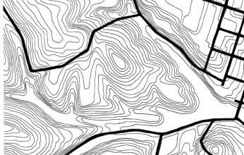
1. The existing topography and road infrastructure |
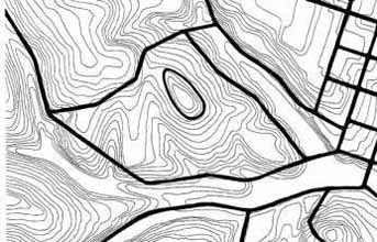
2. Proposed loop road and hilltop park |
|
This 75 acre site abuts the southwestern edge of the town. It is separated from the street grid by a low lying seasonal wetlands. There is a gentle slope that averages around ten percent. At the center of the site is a distinctive egg shaped hill, from which the Sacramento River can be seen. This area has been used for grazing and forage crops. There are no trees on the site. Like much of Rio Vista, the site is windy. It is bounded by Montezuma Hills Road to the South and by a residential neighborhood to the northeast. There are service roads to the north which connect the natural gas pump wells that dot the Montezuma Hills landscape. |
The initial proposed infrastructure is a loop road that connects to the existing town grid and the existing gas service roads. These service roads will be maintained as a base for new infrastructure. The new loop road is structured so that it allows for one lot deep development at the perimeter while still preserving the low lying seasonal wetlands. Another road is located at the highest point of the site to preserve the hilltop as a park, with a series of lots facing onto it. The location of these roads is consistent with general plan guidelines for Rio Vista, which call for the preservation of the hilltop and valley landscape. |
|
|
|
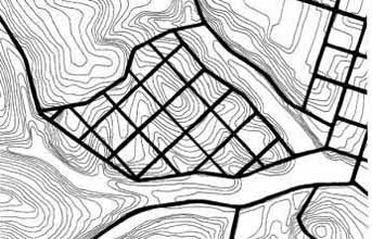
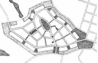
| 3. The existing town grid of Rio Vista superimposed over the Montezuma Hills site | 4. Proposed block structure connected by vehicular roadways, pedestrian paths and public open space |
|
This sketch shows the existing pattern of a 300’ center line to center line street grid of the old town of Rio Vista superimposed over the Montezuma Hill site. In the existing old town the general scale of streets and blocks is quite pleasant, although in its many of the roadways of the residential streets feel too wide, with too much asphalt. This block layout allows for ten 50’ x 150’ lots per block, at a density of about seven single family lots per acre. |
The block layout shown here preserves the hilltop and valley system of the Montezuma Hills and is similar to finer grain scale of blocks of the old town. The blocks are irregularly shaped in order to accommodate the irregular boundaries of the site and the road infrastructure that follows the topological character of the site. In area the blocks are similar to the existing blocks of Rio Vista. There is a hierarchical road system, with a two lane two way loop road circling the site and narrower one lane two way streets connecting across the site. A series of pedestrian paths connects the hilltop and valley open spaces. |
|
|
|
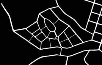
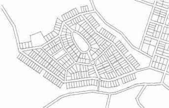
| 5. Subdivision layout | 6. The connections between public open space and pedestrian paths |
|
This subdivision layout shows 282 lots which are an average size of 50’ wide x 120’ deep. These are similar in size to those now existing in the old town as is the corresponding overall density of development. Many corner lots might be double lots, for larger houses. |
Within the street network of the new neighborhood will be a series of public open spaces of different scales. These include the egg shaped hilltop park, a medium scaled rectangular green, smaller neighborhood greens, as well as key lots that will remain open for connection to the seasonal wetlands valley system as well as for possible future connections to other subdivision development. All of these public spaces will be linked by a network of pedestrian paths that connect as well to the pedestrian sidewalks of the tree lined vehicular streets. |
|
FORWARD TO RIO VISTA PART III: SUSTAINABLE DEVELOPMENT & PATTERNS & TYPOLOGY |
|
|
BACK TO TOWN PLANNING PROJECTS
|
|
|
|
|||||